I’ve spent hours and hours pouring over this map of Toronto from 1916. What a different time for our city!
Here are a handful of notable changes from the city that was – almost a century ago…

Thanks to blog reader Joe Q. for providing the link to this map from the Univeristy of Toronto archives a few weeks ago.
Ever since Mrs. Withers took us on a class trip to the St. Lawrence Market back in grade eight, I’ve been fascinated with Toronto’s history.
Here in North America, we don’t have nearly the history of cities in Europe where you can trace streets or buildings back thousands of years. But what we do have is still interesting, and when Joe Q. sent me the link to that map last week, I spent hours looking it over.
Here are a few choice points of interest…
For those of you that live in Liberty Village, have you ever wondered what was there before your lovely townhouse was built on Western Battery Road?
Do you ever lay in bed at night, rattled by the ghosts of the old Central Prison?
That’s right – a prison!

The prison opened in 1873 and its inmates were tasked with building railway cars as a form of “rehabilitation.”
In 1915, the prison was closed, and eventually it was converted to an army base and a processing centre for new immigrants.
Majority of the facility was demolished in 1920 and the land was used by the railway companies.
The only remaining part of the original jail that remains today is the Roman Catholic Chapel, which sits in between Lynn Williams and East Liberty Street. You might recognize this building:
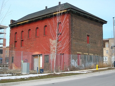
It was designated historical in 1985, so it’s not going anywhere any time soon. So sorry, evil condo developers!
Just north of Liberty Village, closer to Queen Street, we’re all familiar with CAMH – the Centre for Addiction and Mental Health.
Of course, it wasn’t always home to CAMH. Or maybe it was, and we just deat with things differently one hundred years ago than we do today. As a society, I’d like to think we’ve come along way from the days when CAMH was known as….
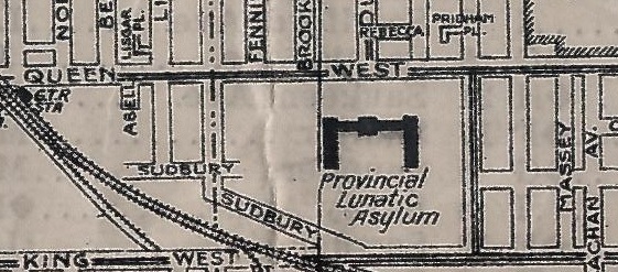
…..the Provincial Lunatic Asylum!
There’s the difference. One-hundred-years ago, we simply locked up the “crazies” and threw away the key. Today, we help them, no matter what their problems, or what the cost associated with the help. No, I’m no socialist, but I’m proud of the social programs we have in this country, and every time I hear the Republican audience of a GOP debate shout, “Let them die,” in response to what should be a rhetorical question, I’m even prouder to live in Canada…
Another interesting pattern I noticed is that many of today’s major streets had different names 100 years ago.
Dundas Street is one of the most well-known streets in our downtown core. You think “Dundas” and you think of the Eaton Centre and Yonge/Dundas Square. But back in 1916, Dundas Street was known as “Wilton Avenue”:

Even cooler perhaps was the inclusion of “Duke Street” and “Duchess Street” down in the St. Lawrence Market area:
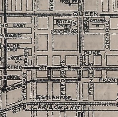
It makes sense.
King, Queen, Princess, Duke, and Duchess!
I went back and looked at the area I grew up – in Leaside, and there are dozens of different street names!
Bessborough Drive, for example, was known as “Edith Avenue,” and “Airdrie” was, for some reason, only Aird:

In addition, Parklea was “Phippen,” Donlea was “Donald,” and Broadway was “Pine Park Avenue.”
Some of the landmarks themselves have been renamed.
Just think of what a large, notable sight Chrstie Pits Park is today, but one-hundred years ago it was known as Willowvale Park:
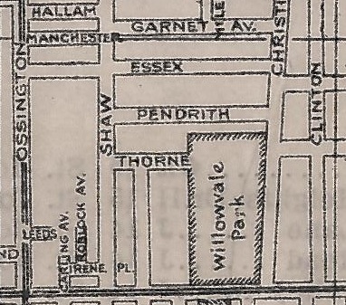
I’m not sure how they even got to Willowvale in the first place! Follow the Christie trail!
The Christie Sand Pits were on the site until the early 1900’s, and were named after Christie Street itself, which was named after William Christie, aka “Mr. Christie” of the cookie fame.
So when the sand pits ceased to exist, wasn’t it a natural course of action to just name it Christie Pits Park? Perhaps they wanted to distance themselves from the sand dunes, but maybe the Willowvale name never caught on. Maybe Toronto residents kept calling it “Christie Pits” the way I refer to the Rogers Centre as “Skydome”…
There are also some major gaps in the old map and I’m wondering if the map itself didn’t include major roads and bridges, or if they just weren’t there.
Here is the the Don River, with Leaside to the north, and East York to the south:

What’s missing?
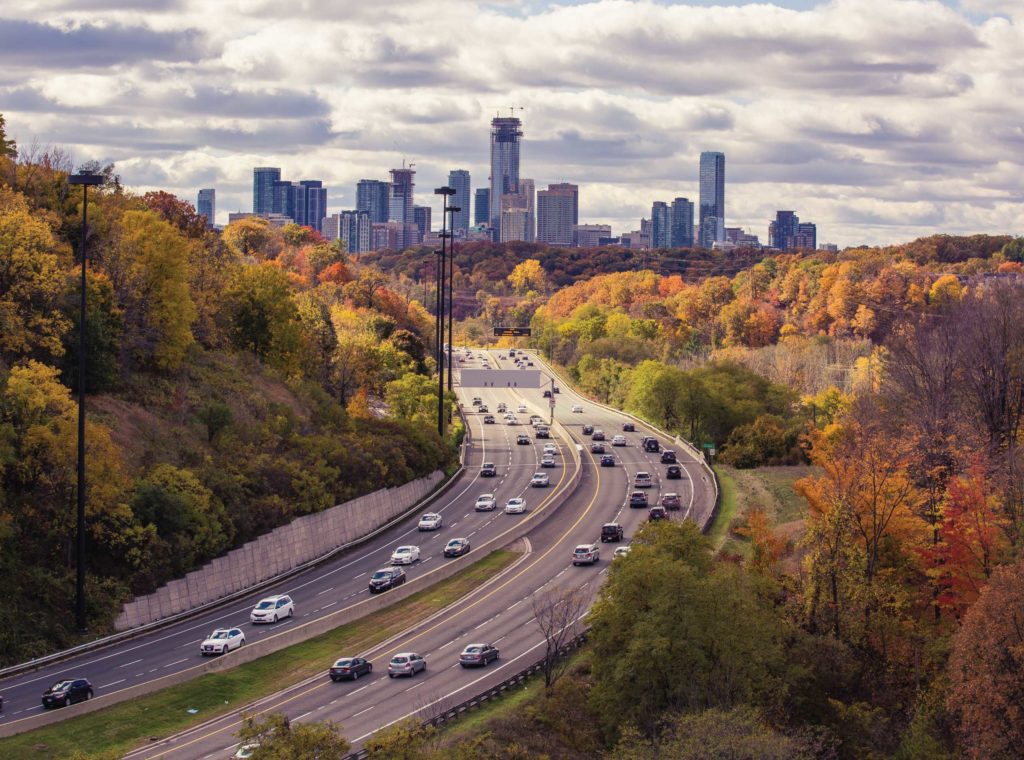
Well, how about a giant bridge that would enable us to get over the Don River and two railway lines? The Don Valley Parkway wasn’t opened until 1961, so back in 1916, there was just a valley below.
Have a look at the map today:

The interesting thing is – East York itself was quite barren in 1916:

For those of you that want to play around with the map, here’s the link:
http://maps.library.utoronto.ca/datapub/digital/G_3524_T6_16_1916.jpg
A word of caution: this map is addictive.
If you are grinding out a typical 9-to-5, you’re going to get very little work done today.
Or perhaps you’re just not in to the old, dusty, hand-drawn archives of Toronto.
Either way, have a great weekend, and we’ll talk about more of Toronto’s history next week!













buk
at 9:00 am
The chapel in liberty village will be the new home of the Miller Tavern.
Brent
at 3:24 pm
Is this a fact?
buk
at 10:47 am
yes sir.
Joe Q.
at 11:13 am
Very glad you enjoyed it, David — I agree that it’s addictive.
I originally got the link from an article on the Spacing magazine blog. The context was a story about Dundas St and its evolution. The article pointed out that in 1916, Dundas came from the west over to Ossington, then took a turn south and ended at Queen St (i.e. the segment of Ossington between Dundas and Queen was then actually called Dundas). Over the years a number of east-west streets at about the same “latitude” were stitched together, enlarged, and renamed to give us the Dundas we know today.
When you drive along Dundas you can see how that might have happened — there are lots of small shifts in alignment (e.g. at University) to the north and south. You can also see it in the very residential nature of Dundas in the east end (including garages etc. on what was once obviously an alleyway). A similar process obtained for Dupont, Rogers Road, and a number of other streets — the evidence for older streets being “stitched together” is right there when you drive them, and are usually confirmed by this 1916 map.
My neighbourhood near Dufferin and St Clair looks totally different today than it did in 1916. Ossington continues all the way up to St Clair (that segment is now called Winona Dr) Many side-streets make the steep drop down from St Clair to Davenport, whereas today very few do so.
Those familiar with the Cedarvale area (west of Bathurst, around Eglinton) will find that the layout and naming of streets is very different than it is today. As one goes farther north, the layout of the city becomes increasingly unrecognizable.
There are a lot of reasons why streets would have been renamed — to avoid confusion (perhaps there were two “Aird Drives”) or to honour people (the Earl of Bessborough was our Governor-General in the 1930s and I guess Leaside seemed as good a place as any to rename a street in his honour — thank you Wikipedia!)
All in all, a fascinating map, and an interesting trip through history. In 1916 Toronto had under 500,000 people total, almost entirely of Anglo-Saxon or Irish ancestry (with some Jews in the mix), and most of its young men were off at war in Belgium or France. Things certainly have changed.
Joe Q.
at 11:23 am
Also wanted to add that Duke and Duchess Streets are still there — but we now know them as Adelaide and Richmond. Both of them have a little jog to the south, just west of Jarvis, that lines them up with old alignments of Duke and Duchess. Pretty cool.
cj
at 5:29 pm
You can still see “Duke” on the old Christie Biscuit Factory (now a Geroge Brown building) at Adelaide and Frederick:
http://maps.google.ca/maps?q=200+king+east,+toronto&ll=43.651822,-79.370095&spn=0.000004,0.002307&sll=43.650911,-79.370217&layer=c&cbp=13,157.74,,1,0.98&cbll=43.651848,-79.369985&gl=ca&hnear=200+King+St+E,+Toronto,+Ontario+M5A+3W8&t=m&z=19&vpsrc=6&panoid=qEUeeDEAhPTWFOEDCaboJg
I believe the names were changed (and the jog added to line up with the original Adelaide & Richmond) when the DVP was built.
dunky
at 11:37 am
What have you been pouring on this map? I hope it didn’t stain.
Anal
at 9:30 pm
Ha. Yes, the correct spelling in this context is “poring”.
Brent
at 3:24 pm
Awesome article! I love that you take the time to put together something like this, and I truly respect your passion for the city of Toronto. It’s interesting because a post like yesterday’s will bring out those haters and might turn people away from your blog, but then a post like today’s shows people that it’s all part and parcel of a passionate view of Toronto. Agree or disagree, it can’t be denied that you love the city, you write about it daily, and your efforts should be applauded. Great work! 🙂
Jamie
at 9:23 am
I love looking at old maps too. It’s fascinating to discover and explore what an area that you are so familiar with today looked like 50, 100, or 200 years ago.
With this in mind, I wanted to make a very strong recommendation for a book called “Historical Atlas of Toronto”. This book tells the story of how Toronto came to be the city it is today through a series of old maps. You think you can kill a lot of time pouring over one map? Try a whole book of them! 🙂
http://www.chapters.indigo.ca/books/Historical-Atlas-of-Toronto-Derek-Hayes/9781553654971-item.html
carol chambers
at 4:44 pm
I have given you my e-mail address…….I have a questin regarding a location in toronto that I can’t figure out. It was 1902, my moms aunt was killed by a train. I have the street she was killed on and I was wondering if you could clear up for me the location?
Thank you,
Carol
dave
at 1:50 am
2012 is off to a great start. People seem to have an interest in buying this year. 2011 business was down, but that is real estate. Great website here. Best of luck to everyone in 2012, realtors, purchasers and sellers.
Kevin Lapierre
at 8:34 pm
I it true that toronto or York as it was called went as far north as Bloor?The rest was farmland.
Richard
at 8:35 pm
I seem to recall the park on the south side of Bloor opposite Christie Pits was called Willowvale.